Project Summary
The proposed Grandpark Brookfield Specific Plan (GBSP) Area consists of approximately 3,484.1 acres located east of State Highway 99, west of the Natomas East Main Drainage Pond, north of the City of Sacramento and proposed Grandpark Southwest Specific Plan, and south of Sutter County and Agricultural lands. The GBSP establishes a framework and strategy for development of the plan area, including proposed land use designations, policies, development and design standards, and plans for infrastructure and public services. The plan provides for 15,944 housing units with a mixture of densities that supports all population segments; 29 active parks; and an extensive plan-wide multi-use trail system.
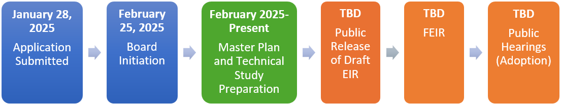
Project Timeline
Specific Plan Supporting Documents
Frequently Asked Questions
A detailed policy plan that identifies allowable land uses and infrastructure needs for a specific geographic area. Specific Plans typically include a land use plan, policy document, transportation plan, drainage plan, water supply plan, public facilities financing plan, urban services plan, and more. Specific Plans are intended to be a comprehensive guide for the physical development of a community at a more detailed level than the General Plan. Future zoning, subdivision, and public works decisions must be in compliance with adopted Specific Plans. Specific Plans are authorized by California Government Code Sections 65450-65457. They can be as general as providing broad policy concepts or as detailed as providing direction for every aspect of development.
Specific Plans may be primarily applicant led or a collaborative effort between the County and Plan proponents. The County is the governing jurisdiction and lead agency. In this case, the Applicant submitted the proposal and materials to the County. The County reviews the proposal for consistency with the General Plan and other policy documents; assesses the potential environmental impacts of a proposal; coordinates with other County departments and government agencies such as neighboring jurisdictions, Water, Fire, Sewer, Air Quality, and Parks districts, and State and Federal agencies; conducts public outreach; and ultimately determines whether to approve or deny the Specific Plan. Upon adoption the Specific Plan is implemented through development proposals which the County reviews for consistency with the Specific Plan.
In response to separate development proposals in the Natomas Basin by the City and County of Sacramento in the 1990s, both jurisdictions recognized the benefits of coordinating their efforts. This collaboration led to the creation of the City/County Joint Vision for Natomas, formalized through a Memorandum of Understanding. This agreement outlined a shared vision for land use and revenue-sharing principles in the Natomas area. As part of this initiative, four planning areas or "precincts" were designated within the Natomas Joint Vision Area: Grandpark (formerly the North Precinct), the West Precinct, the South Precinct, and the Upper Westside (previously known as the Boot Precinct). In 2011the Natomas Joint Vision Study Area overlay was added to the General Plan land use diagram. The intent of this overlay was to identify land within the vision area where the expansion of development was planned. As the Plan Area is outside of the Urban Policy Area and Urban Services Boundary, development of this area requires preparation of a master plan. In this case, the applicants propose a Specific Plan, one of many comprehensive master-planning tools.
Large-scale development is often influenced by a range of factors, including global and domestic politics, economic conditions, and supply chain availability. Build-out for a plan of this scale typically occurs over a 20- to 30-year period. In most cases, infrastructure and residential development are prioritized early on to establish a critical mass of residents, which in turn supports future commercial and institutional uses. The pace of construction can vary, but may average several hundred dwelling units and a significant amount of non-residential square footage per year, depending on market conditions and developer interest.
The Grandpark Brookfield Specific Plan provides for future development. It does not require current property owners to do anything with their properties. Existing uses, such as residences and businesses, may continue to exist and operate until such time that the property owner chooses to pursue new development or a different use. If adopted, the Grandpark Brookfield Specific Plan would allow for development consistent with its proposed land uses and policies. Development consistent with the proposed land uses will require planning entitlements such as a Rezone, Tentative Subdivision Map, and Design Review.
Please refer to the Project Timeline on this webpage or contact the County for specific information.
If you have an inquiry or comment please contact the Project Manager: Emma Patten, Senior Planner, (916) 875-4197, pattene@saccounty.gov or Lead Planner: Emma Carrico, Associate Planner, (916) 876-1215, carricoe@saccounty.gov.
Contact
Sacramento County Planning and Environmental Review
Emma Patten, Senior Planner Emma Carrico, Asscociate Planner
(916) 875-4197 (916) 876-1215