Project Summary
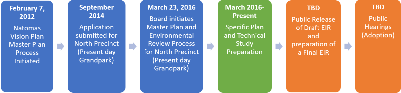
The Grandpark Specific Plan (formerly North Natomas Precinct and part of the Natomas Vision Plan) has had a detailed and lengthy history. In September 2014, the Grandpark Landowners' Group submitted an application that was later modified to include urbanization for the area north of Elkhorn Boulevard and east of Highway 99. The Master Plan process continues the effort begun many years ago and includes opportunities for public comment and input.
The area includes numerous important assets and unique opportunities to the County and the Region. The area contains the intersection of two major north/south and east/west interstates; will be served by the future Downtown/Natomas/Airport Light Rail line; is within four to seven miles of downtown Sacramento; and is identified as a future growth area in the regional “Blueprint” Plan. The Sacramento International Airport represents a significant investment of both public and private funds and is a major regional economic asset. Immediately to the east of the airport is the Metro Airpark business park that in the future will be available for construction of major employment and business activity. In addition, major investments of local, state and federal funds are underway to complete massive levee improvements in order to protect existing homes and residents, the airport, the interstate freeways and other significant investments within the larger Natomas Basin. Finally, solutions to addressing the preservation of habitats and species, notably the Swainson’s Hawk and Giant Garter Snake, are being studied and will be an important component of the planning process.
Project Timeline
 Planning Documents
Environmental Documents
Frequently Asked Questions
A detailed policy plan that identifies allowable land uses and infrastructure needs for a specific geographic area. Specific Plans typically include a land use plan, policy document, transportation plan, drainage plan, water supply plan, public facilities financing plan, urban services plan, and more.
Specific Plans are intended to be a comprehensive guide for the physical development of a community at a more detailed level than the General Plan. Future zoning, subdivision, and public works decisions must be in compliance with adopted Specific Plans. Specific Plans are authorized by California Government Code Sections 65450-65457. They can be as general as providing broad policy concepts or as detailed as providing direction for every aspect of development.
Specific Plans may be either primarily applicant or may be a collaborative effort between the County and Plan proponents. The County is the governing jurisdiction and lead agency. In this case, the Applicant submitted proposals and materials to the County.
The County reviews these proposals for consistency with the General Plan and other policy documents; assesses the potential environmental impacts of a proposal; coordinates with other County departments and government agencies such as neighboring jurisdictions, Water, Fire, Sewer, Air Quality, and Parks districts, and State and Federal agencies; conducts public outreach; and ultimately determines whether to approve or deny the Specific Plan.
Upon adoption the Specific Plan is implemented through development proposals which the County reviews for consistency with the Specific Plan.
In response to separate development proposals in the Natomas Basin by the City and County of Sacramento in the 1990s, both jurisdictions recognized the benefits of coordinating their efforts. This collaboration led to the creation of the City/County Joint Vision for Natomas, formalized through a Memorandum of Understanding. This agreement outlined a shared vision for land use and revenue-sharing principles in the Natomas area.
As part of this initiative, four planning areas or "precincts" were designated within the Natomas Joint Vision Area: Grandpark (formerly the North Precinct), the West Precinct, the South Precinct, and the Upper Westside (previously known as the Boot Precinct).
In 2011 the Natomas Joint Vision Study Area overlay was added to the General Plan land use diagram. The intent of this overlay was to identify land within the vision area where the expansion of development was planned. As the Plan Area is outside of the Urban Policy Area and Urban Services Boundary, development of this area requires preparation of a master plan. In this case, the applicants propose a Specific Plan, one of many comprehensive master-planning tools.
Large scale development can be impacted by many factors such as global and domestic politics, economic conditions, and supply chains. The Grandpark Specific Plan has a build-out is anticipated to occur over a 20-year timeframe.
Typically, infrastructure and residential development will proceed first in order to attract a critical mass of residents needed to support commercial and institutional uses.
The Grandpark Specific Plan provides for future development. It does not require current property owners to do anything with their properties. Existing uses, such as residences and businesses, may continue to exist and operate until such time that the property owner chooses to pursue new development or a different use.
If adopted, the Grandpark Specific Plan would allow for development consistent with its proposed land uses and policies. Development consistent with the proposed land uses will require planning entitlements such as a Rezone, Tentative Subdivision Map, and Design Review.
Contact
Sacramento County Planning and Environmental Review
Emma Patten, Senior Planner
(916) 875-4197
pattene@saccounty.gov