Provenance Specific Plan
Project Summary
The proposed Provenance Specific Plan (PSP) (formerly GrandPark Southwest Specific Plan) area consists of approximately 1,871.2-acres located east of State Highway 99, west of the proposed GrandPark Brookfield Specific Plan, south of West Elverta Road, and north of the City of Sacramento in the Natomas Community. The PSP establishes a framework and strategy for development of the plan area, including proposed land use designations, development and operation policies, and plans for infrastructure and public services. The Specific Plan provides for 8,589 housing units with a mixture of densities that supports all population segments; 27 active parks; and an extensive multi-trail system throughout the plan area. For more details and a list of the entitlements requested with the application please see the Project Description.
Project Timeline
Updates and Upcoming Events
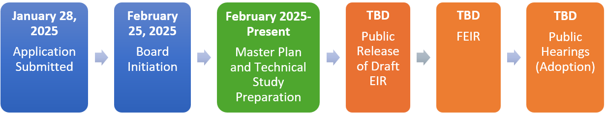
1. Notice of Preparation (NOP): A NOP was released on May 15, 2025, and scoping meetings were held on May 29, 2025. The comment period for the NOP closed on June 16, 2025.
2. Specific Plan and Technical Study Preparation: The applicant is working with County staff and service providers to develop the Specific Plan and technical studies to support the project.
3. Natomas CPAC Workshop. The Natomas CPAC will meet on March 11, 2026, for a workshop to discuss the Provenance Specific Plan. The workshop will be held in the Board Chambers located at 700 H Street, Sacramento, CA 95814 at 6:00 PM. Directions and parking information can be found here.
Specific Plan Supporting Documents
- Project Description
- Specific Plan Project Area
- Draft Land Use Plan
- Draft General Plan Amendment – Urban Policy Area
- Draft General Plan Amendment – Urban Services Boundary
- Draft General Plan Amendment – Land Use Diagram
- Draft General Plan Amendment – Active Transportation Plan
- Draft General Plan Amendment – Transportation Plan
Environmental Documents
Frequently Asked Questions
A detailed policy plan that identifies allowable land uses and infrastructure needs for a specific geographic area. Specific Plans typically include a land use plan, policy document, transportation plan, drainage plan, water supply plan, public facilities financing plan, urban services plan, and more. Specific Plans are intended to be a comprehensive guide for the physical development of a community at a more detailed level than the General Plan. Future zoning, subdivision, and public works decisions must be in compliance with adopted Specific Plans. Specific Plans are authorized by California Government Code Sections 65450-65457. They can be as general as providing broad policy concepts or as detailed as providing direction for every aspect of development.
Specific Plans may be either primarily applicant or may be a collaborative effort between the County and Plan proponents. The County is the governing jurisdiction and lead agency. In this case, the Applicant submitted proposals and materials to the County. The County reviews these proposals for consistency with the General Plan and other policy documents; assesses the potential environmental impacts of a proposal; coordinates with other County departments and government agencies such as neighboring jurisdictions, Water, Fire, Sewer, Air Quality, and Parks districts, and State and Federal agencies; conducts public outreach; and ultimately determines whether to approve or deny the Specific Plan. Upon adoption the Specific Plan is implemented through development proposals which the County reviews for consistency with the Specific Plan.
Development in the Natomas Basin has been contemplated dating back to 1990. In 2011, the Natomas Joint Vision Study Area overlay was added to the General Plan land use diagram The intent of this overlay was to identify land within the vision area where the expansion of development was planned. As the plan area is outside of the Urban Policy Area and Urban Services Boundary, development of this area requires preparation of a master plan. In this case, the applicants propose a Specific Plan, one of many comprehensive master-planning tools. The Specific Plan is required to demonstrate consistency with the General Plan’s Growth Management Strategy including compliance with LU-119, LU-120, and LU-127.
Large-scale developments are influenced by a variety of factors, including global and domestic politics, economic conditions, and supply chain dynamics. The Grandpark Southwest Specific Plan is expected to be built over approximately 30 years, with the first residential units anticipated to begin construction around 2030.
The Provenance Specific Plan provides for future development. It does not require current property owners to do anything with their properties. Existing uses, such as residences and businesses, may continue to exist and operate until such time that the property owner chooses to pursue new development or a different use. If adopted, the Grandpark Southwest Specific Plan would allow for development consistent with its proposed land uses and policies. Development consistent with the proposed land uses will require planning entitlements such as a Rezone, Tentative Subdivision Map, and Design Review.
Please refer to the Project Timeline higher up on this page or contact the County for specific information.
If you have an inquiry or comment please contact the Project Manager: Emma Patten, Senior Planner, (916) 875-4197, pattene@saccounty.gov or Lead Planner, Christopher Alberts, Associate Planner, (916) 874-4136, albertsc@saccounty.gov
You can sign up to receive email updates regarding this project on the County's website.
Contact
Sacramento County Planning and Environmental Review
Emma Patten, Senior Planner
(916) 875-4197
pattene@saccounty.gov
Christopher Alberts, Associate Planner
(916) 874-4136
albertsc@saccounty.gov